
Start a National City Street Directory Trail
A current street directory search starts with the ground, not a guessed name. Locate the parcel that carries the address, save its assessor parcel number, and then ask each custodian a narrow question. SanGIS can show the physical lot and its surrounding lines. County assessor channels can connect that parcel to ownership, value, sales, and property characteristics. The recorder can connect an owner to an acquisition document. Permits can add a dated project trail. Each result describes a role at a point in time, not a complete list of people at the address.
- Enter the address in the SanGIS parcel viewer and select the matching parcel. Record the APN, nearby parcel shapes, road name, and municipal or ZIP layers before moving on.
- Take the APN to ARCC assessor channels. Request or inspect the owner, property address, value, sales, and characteristics, while keeping the physical situs address separate from the owner mailing address.
- Search the current owner as a grantee in the ARCC recorder index. Read the acquisition document, note the seller and legal description, then search that seller as a grantee for the prior transfer.
- Use California My Voter Status only for a voter checking their own record. A formal voter-file application has purpose and handling limits, so it is not a public street list.
- For an older household clue, consult the Kile Morgan local-history shelf and its reverse directory material. Compare the address with a dated map or newspaper before treating a name as a former householder.
The sequence keeps a map, an owner record, a title document, and a historical address clue in their proper lanes. It also provides a fallback when a name search is common or an online field is restricted. An address trail becomes dependable through agreement among dated sources, not through one broad result.
National City Address Records
National City address records sit in several offices. ARCC combines assessor, recorder, and county-clerk functions, while SanGIS and SANDAG supply the parcel map. The City Building Division keeps project files, and California election systems protect voter data from casual street browsing. The table separates what each source can contribute to a by-address search from the way a researcher reaches it.
| Record Set | Keeper | Street Signal | Access Path |
|---|---|---|---|
| Assessor property information | San Diego County ARCC | Owner, property address, value, sales, and characteristics | Assessor Public Information at 619-236-3771, public kiosk, or ParcelQuest |
| Assessor map | San Diego County ARCC | APN, lot dimensions, boundaries, adjoining parcels, and map references | Web map, copy, or counter service; the map omits ownership and street address |
| Parcel GIS | SanGIS and SANDAG | Address and APN geometry, roads, jurisdictions, ZIP and district layers | Free map, parcel click, print, save, or export |
| Recorded instruments | ARCC Recorder | Grantor, grantee, document type, recording date, number, and legal description | Online name index from 1970, kiosks, mail, or County Archives |
| Building and engineering files | National City Building Division | Project address or APN, participants, work, valuation, and plans | City request or counter service at the Building Division |
| Voter information | California Secretary of State and county Registrar of Voters | Self-status or a restricted file, not an open list of occupants | Identity-gated self-lookup or an application for a permitted purpose |
The strongest current chain is SanGIS parcel to ARCC assessor channel to recorder instrument, with a permit used as dated context. A tax mailing address can differ from the situs address. A named owner can live elsewhere. A permit applicant can be an architect, contractor, business, or owner. Those distinctions keep by-address research from turning a record role into an unsupported claim about residence.
Map National City Streets in SanGIS
The SanGIS/SANDAG Parcel Lookup Tool is the best first map for walking a National City street parcel by parcel. It locates geography. It does not establish who lives there. Search controls and outputs documented for the viewer are compact enough to record before the map is used as a bridge to ARCC.
| Field or Control | Type | Required | What It Does |
|---|---|---|---|
| Address | Text or locator | One search mode | Finds a parcel by address |
| APN | Identifier | One search mode | Finds a parcel by assessor parcel number |
| Street intersection | Locator | One search mode | Finds a cross-street area |
| Layer visibility | Toggle or check | No | Turns on more than 33 layers |
| Parcel selection | Map click | No | Opens an individual parcel report |
| Print, save, or export | Output | No | Preserves a map or exports parcels, roads, and address points |
Turn on parcel and APN labels first. Roads and municipal boundaries help distinguish a real edge from a similar street number. Census tract, block group, block, ZIP, school, fire, cemetery, and transit layers add geographic context. Click the target parcel, then adjacent polygons, and preserve each APN. The viewer documentation does not confirm a radius, buffer, or multiselect control, so sequential map clicks are the sound method for a small street study.
Note: SanGIS maps physical boundaries and districts, while ARCC records supply the ownership and recorded-document trail tied to the parcel.
Use ParcelQuest for National City Addresses
ARCC assessor property information can supply ownership, property address, assessed value, sales listings, and characteristics through phone help, public computers, or ParcelQuest. California law limits general Internet display of ownership information, so an address guide should not promise a simple public owner-name search. Call Assessor Public Information at 619-236-3771 when the online route does not answer the parcel question. The assessor map is a separate aid: it can show APN, dimensions, acreage on many larger parcels, boundaries, adjoining parcels, and recorded-map references, but it intentionally omits ownership and street address.
For a visual look at the assessor route, use the ARCC ParcelQuest disclosure and entry information before opening a report.
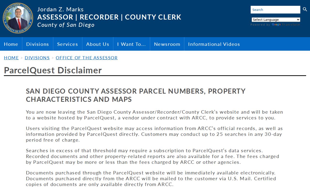
The ParcelQuest entry belongs in the assessor part of the chain, after SanGIS has identified the physical parcel. Its no-cost allowance is 25 searches in any rolling 30 days; a subscription may be required after that threshold. A vendor report is not a county-certified copy. For a specific address, phone or kiosk help remains important when ownership display is suppressed online.
Keep the two addresses in separate notes. The situs address marks the land. The tax mailing address shows where assessment correspondence goes. A mismatch can suggest an absentee owner, but it does not identify the people who use the property or prove where an owner lives.
National City Parcel Terms, Plainly Defined
Address research gets noisy when map terms and record terms are treated as synonyms. Four labels matter in a National City address trail because each points to a different kind of evidence. The definitions below keep a parcel map, an address line, a recorded map, and an older reverse directory from being read as the same thing.
- Parcel
- A mapped unit of land identified by an APN. It is a property geography, not a list of everyone connected with the land.
- Situs address
- The physical location assigned to the parcel. It can differ from the owner mailing address used for tax correspondence.
- Plat
- A recorded map that lays out lots, lines, dimensions, streets, or other boundaries. A deed may rely on that map when an old street label is unclear.
- Criss-cross directory
- A reverse directory organized from an address or householder back to a name. The historical format can reveal a dated occupant clue, not a current household roster.
Use the APN and recorded legal description to join sources. Use the street address to orient the map. Use a criss-cross entry as a historical lead that needs a second source. That small vocabulary check prevents a parcel owner, a mailing destination, and an old householder from collapsing into one asserted identity.
Follow a National City Deed Chain
The ARCC Official Records name index covers 1970 to the present, is updated daily, and can take 24 to 48 hours to reflect a new filing. Search either grantor or grantee. Names appear as written, and records indexed before 2012 may use abbreviations such as BK and CO. Put a trust or organization in Business Name. The index can identify a document; the image or purchased copy supplies deeper legal detail.
- Search the current owner as grantee, using middle initials, spouse names, trust names, and business variants when the first result is unclear.
- Record the document type, recording date, document number, seller or grantor, and legal description from the acquisition record.
- Search that seller as grantee. Compare the APN and legal description instead of relying on a similar name alone.
- Repeat the seller-to-buyer step until the web index ends, then shift to an ARCC kiosk, County Archives, or the Kile Morgan collection for earlier material.
Since December 9, 2024, AB 1785 has removed APN search from the online recorder index. All five ARCC public kiosks retain APN searching and show images free for viewing. Online orders require an account and are mailed, generally three to five business days after printing. The published recorder schedule lists $2 for the first page, $0.05 for each added page, $1 for certification, and a $2.50 card surcharge.
For a counter route, the nearby Chula Vista ARCC branch is at 590 Third Avenue. Recorder and County Clerk help is 619-237-0502, and ARCCHELP@sdcounty.ca.gov is the county contact. For a mailed copy, send the document number, recorded year, at least one party, and document type to San Diego Recorder/County Clerk, ATTN Real Estate Records, PO Box 121750, San Diego, CA 92112-1750. Pay by check or money order. The stated general mail turnaround is 7 to 10 business days. When the current chain becomes a full backward address history, the National City previous residents search follows that trail in more depth.
Note: The recorder index gives a name path, while the deed image and legal description decide whether two similarly named transfers belong to the same parcel.
National City Permit Files Add Dated Context
National City Building Division files can explain why a person or business appears beside an address on a particular date. The office is at 1243 National City Boulevard and lists 619-336-4210. A permit or engineering file can connect a project to an owner, applicant, contractor, valuation, alteration, plan, or subdivision question. It does not prove that a named person lived at the address. The published permit material does not state a complete starting year, so an old address should not be given an invented permit cutoff.
| Application Field | Address Trail Value |
|---|---|
| Project Address and APN | Joins the project to a physical location and parcel identifier |
| Project Description, Area of Work, and Valuation | Dates the stated scope and scale of construction or alteration |
| Owner name, address, phone, and email | Identifies the owner information supplied for that project record |
| Applicant name, business, address, phone, and email | Shows who submitted or managed the application |
| Contractor identity, contact, license, and business-license dates | Links the work to the contractor details recorded on the application |
Requests can be directed to Building@NationalCityCA.gov or the Building Division. Engineering files and plans are useful when an address has changed form, but they remain project evidence. Put the permit date and role beside every name, then compare it with the deed and assessor trail. That practice keeps construction history from being mistaken for a resident directory.
Read a National City Reverse Directory
The Kile Morgan Local History Room at National City Public Library holds county and city directories from 1889 through 1984, along with maps, newspapers, and local property material. The confirmed 1957 National City Householders Directory is especially useful because it starts with the street or address rather than a person’s name. Older entries can pair an address with a name, occupation, affiliation, or nearby cross-street clue. They remain historical evidence, not a current street register.
The library is at 1401 National City Boulevard. General library service is 619-470-5800; the Kile Morgan room lists 619-470-5870 and localhistory@nationalcityca.gov. Room information shows Tuesday and Thursday access and also uses appointment-only language, so call or email before travel. A reverse entry that disappears in the next volume may reflect canvass timing or an indexing gap. Compare adjacent years and a map rather than treating absence as proof that a household left.
For the shelf, publishers, and entry-reading details, use the National City Directory Book. A by-address search should borrow only the reverse-directory clue it needs, then return to the modern parcel and deed record.
Check National City Street Geography First
Street numbers do not always describe a simple line of neighboring parcels. SanGIS roads, jurisdiction boundaries, rail or freeway edges, canyons, and superblocks can separate parcels that look close in a number sequence. Click the actual polygons and compare the road layer before calling two addresses adjacent. A legal description or recorded map is stronger than a guess based on numbering.
Research has not located a verified National City street-renumbering chronology. Do not assign a year to a supposed renumbering project or silently convert an old address into a modern one. Preserve the wording in the source, compare it with SanGIS geometry, and use the deed legal description, plat reference, newspaper, or Sanborn sheet to test continuity. That gap is part of the evidence, not a reason to invent a tidy timeline.
ZIP geography adds another trap. The Lincoln Acres Classified Station ended service on November 19, 2011, while customers retained National City, California 91950. A postal line can therefore sit outside the incorporated city. Verify a mailing address with the USPS ZIP lookup, then compare SanGIS municipal and ZIP layers. Note: A National City mailing line and a National City city-limit line can describe different geographies for the same address record.
What National City Streets Cannot Show
A parcel record identifies an owner, not every occupant. A tax mailing address identifies a correspondence destination, not a household. A permit identifies a project role, not a residence. The recorder index identifies parties to an instrument, and a court index identifies a case, but neither proves a present home. California My Voter Status authenticates the voter checking their own record. Formal voter data is purpose-restricted under Elections Code sections 2188.5 and 2194 and related regulations, so it is not an open tool for finding everyone on a street.
Lawful personal use. Use National City address records for family history, property research, civic curiosity, or another lawful personal purpose. Do not use a name, parcel, or historical address to stalk, harass, intimidate, or harm anyone.
Some address information is closed or limited for stronger reasons. DMV information is protected by the federal Driver Privacy Protection Act. Safe at Home can create a confidential voter or substitute address for eligible participants. Sealed, juvenile, adoption, and protected vital material may not be available through ordinary searching. A careful search records the boundary instead of filling it with a guess.
Protect a National City Property Trail
The San Diego County OWNER ALERT service is a useful present-day companion to an address study when the concern is a future indexed filing. It is free and can monitor up to ten names and ten APNs per email. An alert does not interpret the document, confirm a resident, or replace the recorder index. Use the document number in the alert to inspect the underlying record and ask ARCC questions when the filing is unclear.
That distinction matters for a long National City address trail. SanGIS establishes place, assessor channels establish the available property facts, deeds establish recorded transfers, permits date project activity, and historical directories add earlier householder clues. Label each result by date and role. A narrow, dated chain is more useful than a broad claim that an address record can reveal every person connected with a parcel.
Note: OWNER ALERT sends filing notices, but it is not a resident tracker and cannot explain what a recorded document means.